OpenStreetMap
How can I add a trail that is missing on the map
2019-09-18 16:48 Stored in:Support
Problem: TrailRunner mini uses the OpenStreetMap network create routes along the transit locations you set. But sometimes the OpenStreetMap data is not complete, misses a link between two paths or has wrong path attributes like planning along a seemingly public way though the way is private or blocked in reality. This may lead to strange routes being calculated by TrailRunner mini.
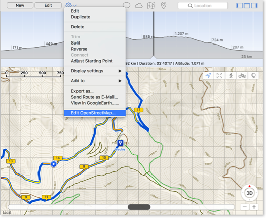
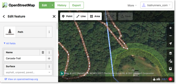
Contribute: OpenStreetMap is like wikipedia for maps. Everyone can contribute, extend and correct the maps. There is a very convenient editor existing you may use to edit the open openStreetMap maps.
After making changes to OpenStreetMap, it takes a couple of hours until your changes have have made it into the routing engine of TrailRunner mini.
As TrailRunner mini may still have cached the old data, use TrailRunner mini > Clear Caches… to make sure the new data is downloaded and becomes visible in the map.
Alternatively you can build a local missing link by creating an off-road section within your planned route.
Can you add more map sources?
2013-08-17 12:26 Stored in:Conceptual
Problem: The map data being displayed by TrailRunner mini misses some trails or streets. But these are visible in other sources like Google Maps. Can you add these maps to TrailRunner mini?
Explanation: TrailRunner mini is based on the OpenStreetMap project. When you create routes, TrailRunner mini follows a hidden network of trails and streets that is based on OpenStreetMap data. The same data is being used to render the visible map. Would I add different map sources like Google Maps, the trail or street may be visible to you but you still cannot use it within the routing editor. This would be very frustrating and therefore I will not add this feature to TrailRunner mini — just because the App is supposed to be a simple route planning tool and no professional mapping solution.
Hint: But what you can do is to contribute to the OpenStreetMap project and fix the problem at its root.
Update: In recent builds of TrailRunner mini and RaceBunny you can choose between different map Sources. But please understand that these still are based on the openStreetMap project data and therefore cover the same level of detail, though the design may differ.
Expert Hint: When you click on the map toolbar icon in TrailRunner mini, select the option to display more map sources. Then choose any of the available. But please understand that these may display different data than the routing editor can display. If that is the case you may use the off-road routing feature to follow these ways.
How can I create off-road routes?
2012-11-21 16:40 Stored in:Help
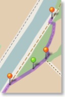
Solution: In the left editor panel, turn on the off-road switch. All now placed transit location pins are now green off-road pins that no longer follow the openStreetMap network. As an alternative, while moving or adding a transit-location, hold the (Command / ⌘) key down to place an off-road transit location. TrailRunner mini will then create a straight connection between the last transit location, the green off-road transit location and the upcoming transit location.
HowTo: Watch this video guide on how this works.
Contribute: To improve the mapping coverage of this area, you may want to contribute to the openstreetmap.org project. Layout the "missing link", export a GPX file and upload it to the openStreetMap network. It may then take up to two weeks until the track is available within TrailRunner mini. If that's not the case, remove the TrailRunner mini Cache from your hard-drive.