routing
How can I create off-road routes?
2013-01-04 22:36 Stored in:Help
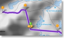
Solution: Transit location pins can be of type off-road. TrailRunner touch will then create a straight connection between the last orange transit location, the green off-road transit location and the upcoming transit location.
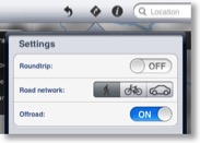
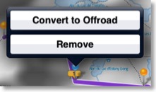
How-To: Either open the routing popover and set the mode to off-road. Then all further pints will be of type off-road. Alternatively convert an exiting pin by pressing on the transit location pin and choosing the corresponding command.
Contribute: To improve the mapping coverage of this area, you may want to contribute to the openstreetmap.org project. Layout the "missing link", export a GPX file and upload it to the openStreetMap network. It may then take up to two weeks until the track is available within TrailRunner touch.
Gestures
2012-04-22 10:59 Stored in:Help
TrailRunner touch supports the following gestures within the main map:


Source: touch reference touch gesture guide: TouchGestureGuide.pdf
 Double-tap with one finger: zooms in on the tapped location.
Double-tap with two fingers: zooms out on the center of the tapped locations
Pinch and Spread: zooms in and out on the center of the touches.
Drag (Tap, hold and move): scrolls the map or moves a transit location
Press (Tap and hold): opens a popover with commands available for the current context.
 Drag: scroll to the map location to the touched elevation location
Drag with two fingers: Select the touched elevation range and scroll to the map
Source: touch reference touch gesture guide: TouchGestureGuide.pdf
Interactions with the map:
Double-tap with two fingers: zooms out on the center of the tapped locations
Pinch and Spread: zooms in and out on the center of the touches.
Drag (Tap, hold and move): scrolls the map or moves a transit location
Press (Tap and hold): opens a popover with commands available for the current context.
Interactions with the elevation chart:
Drag with two fingers: Select the touched elevation range and scroll to the map
How can I edit an imported route?
2012-11-21 18:45 Stored in:Help
Problem: You have imported a GPX file and want to edit the course.
Solution: Select the imported route and in the details popover flag the route. It now is displayed persistently in the background. Now start creating a new route and retrace its course.
Solution: Select the imported route and in the details popover flag the route. It now is displayed persistently in the background. Now start creating a new route and retrace its course.