

TrailRunner Mini

De vrais sentiers, l’aventure.

TrailRunner Mini est fait pour les coureurs, randonneurs, cyclistes et vététistes qui veulent découvrir des chemins au-delà des itinéraires classiques.

TrailRunner Mini est la meilleure application de planification d'itinéraires pour Apple MacBook, iMac, iPad et iPhone.
Hors des sentiers battus

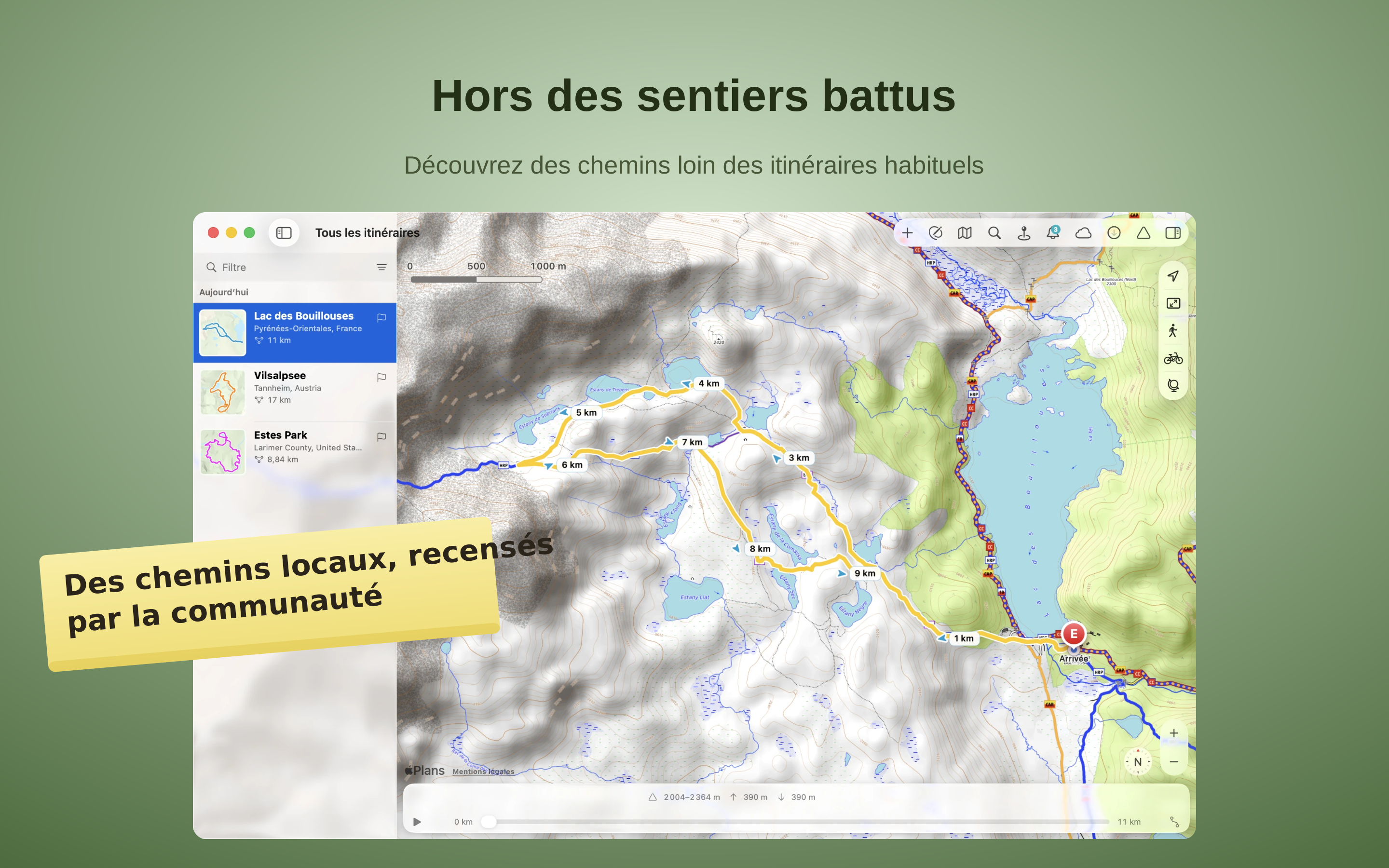
Hors des sentiers battus

TrailRunner Mini planifie vos itinéraires sur OpenStreetMap – une carte entretenue par des gens qui connaissent leur région. Découvrez des sentiers de randonnée balisés, des monotraces et des chemins naturels loin des grands axes. L’ombrage du relief et les courbes de niveau révèlent le terrain et facilitent l’orientation.
Lisez la montagne

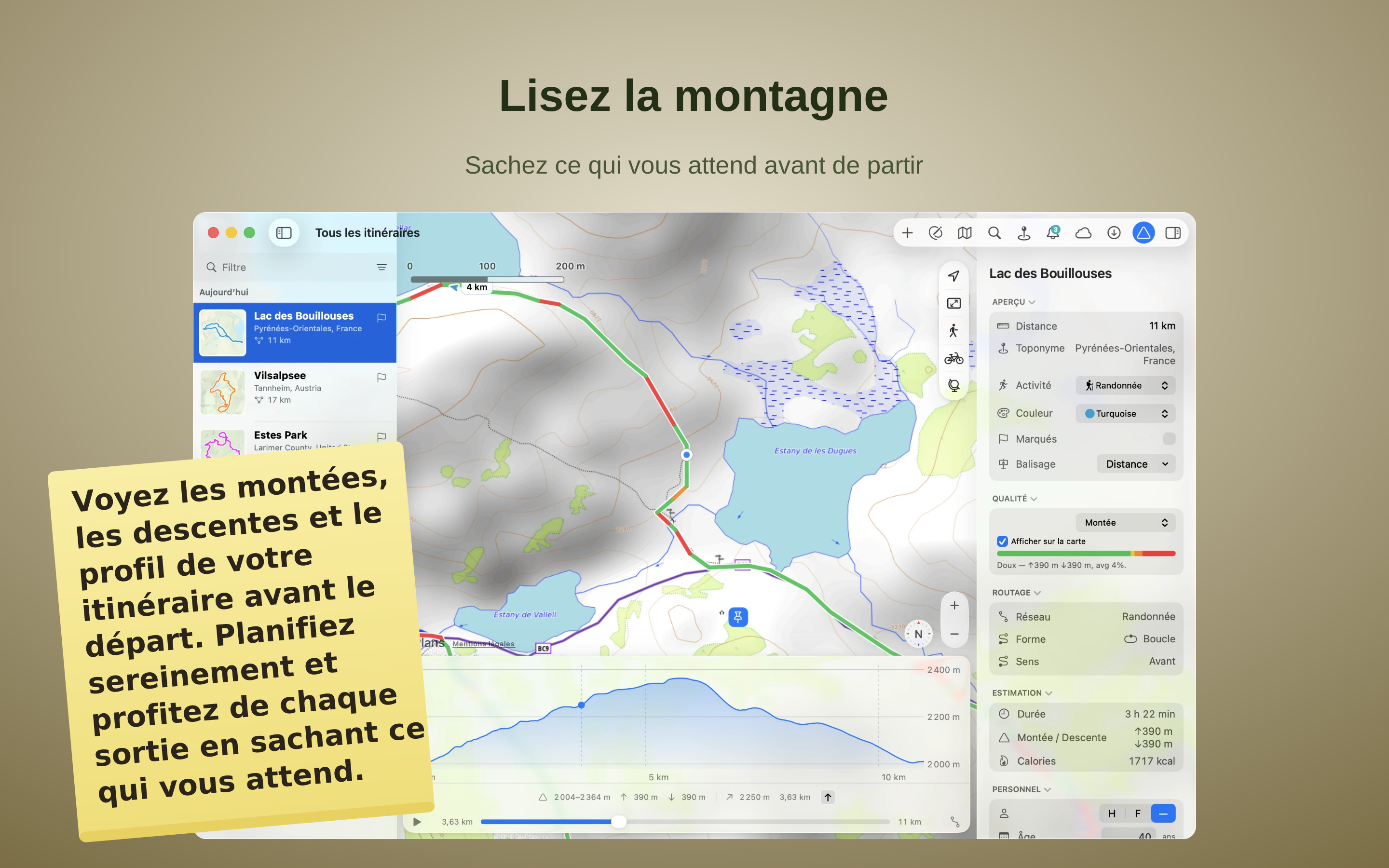
Lisez la montagne

Lisez la montagne avant de partir — et planifiez à l’avance. Chaque itinéraire comporte un profil altimétrique complet : montée et descente en mètres, le point le plus haut et le plus bas, et la pente de chaque section. Pendant que vous construisez un itinéraire, le dénivelé s’additionne en direct, et une barre montre la part de plat, de vallonné ou de raide — vous façonnez ainsi exactement l’effort souhaité, puis vous suivez le profil pour voir où ça monte et où ça descend.
Perdu dans l’instant, jamais perdu

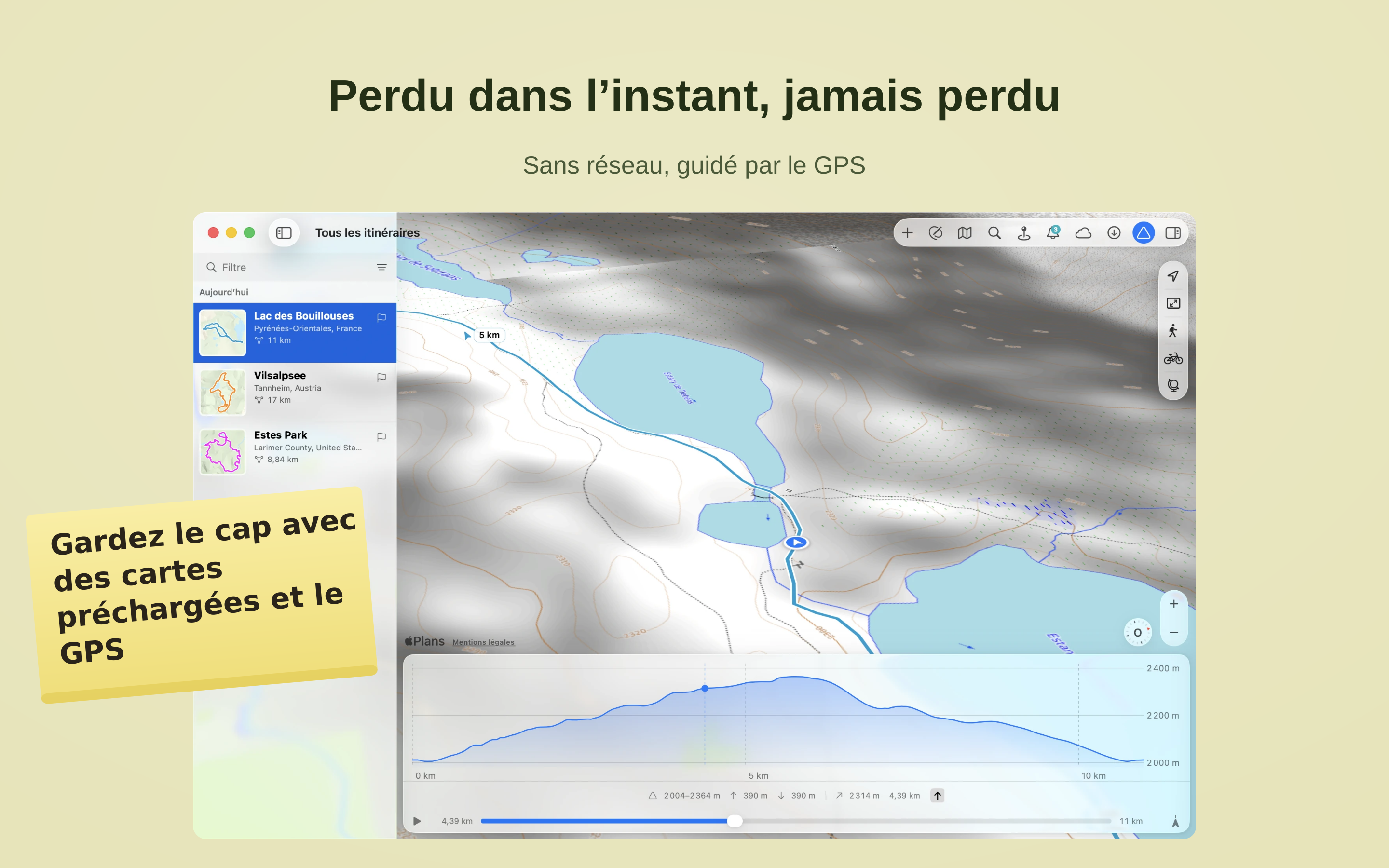
Perdu dans l’instant, jamais perdu

Téléchargez une région à l’avance – la carte et l’orientation continuent de fonctionner même lorsqu’il n’y a plus de réseau mobile et que seul le GPS connaît votre position.
Suivez le vrai balisage

Suivez le vrai balisage

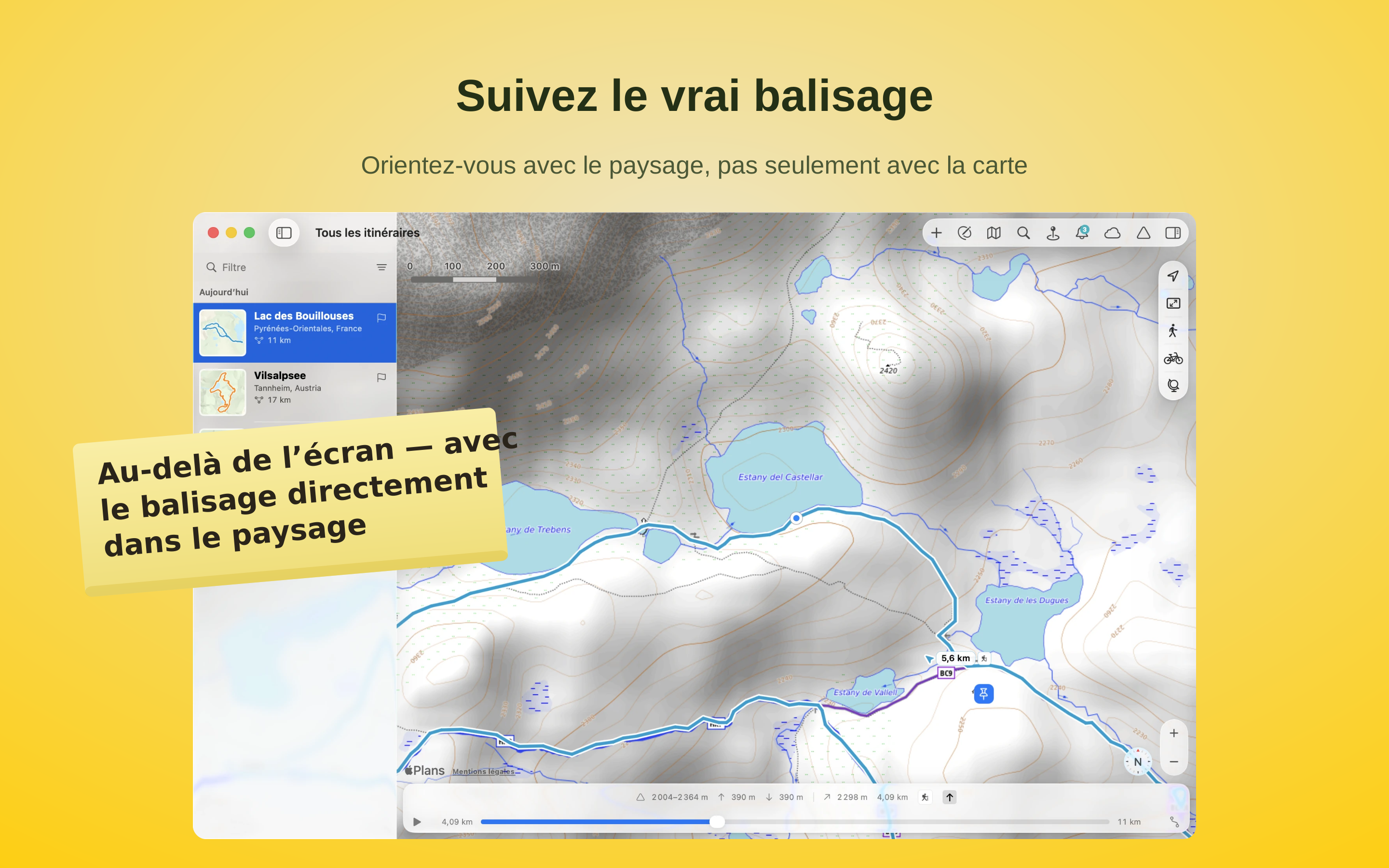
Suivez le balisage officiel, avec ses couleurs et ses symboles caractéristiques. Là où il est recensé dans le réseau officiel des chemins, TrailRunner Mini affiche les mêmes marques que sur le terrain. À chaque intersection, vous voyez aussitôt si vous continuez sur le chemin balisé ou s’il faut bifurquer vers un autre.
Des cartes qui révèlent le terrain

Des cartes qui révèlent le terrain

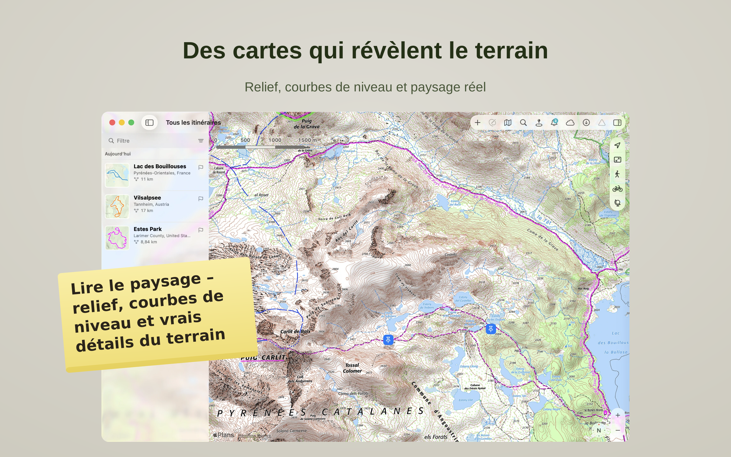
Voyez le relief, pas seulement les traits sur la carte. TrailRunner Mini affiche des cartes topographiques avec estompage et courbes de niveau qui font ressortir crêtes, vallées et sommets d'un coup d'œil, et vous laisse basculer entre de belles cartes régionales. Lisez le terrain autour de votre itinéraire et choisissez les chemins qui lui conviennent.
Planifiez votre boucle parfaite

Planifiez votre boucle parfaite

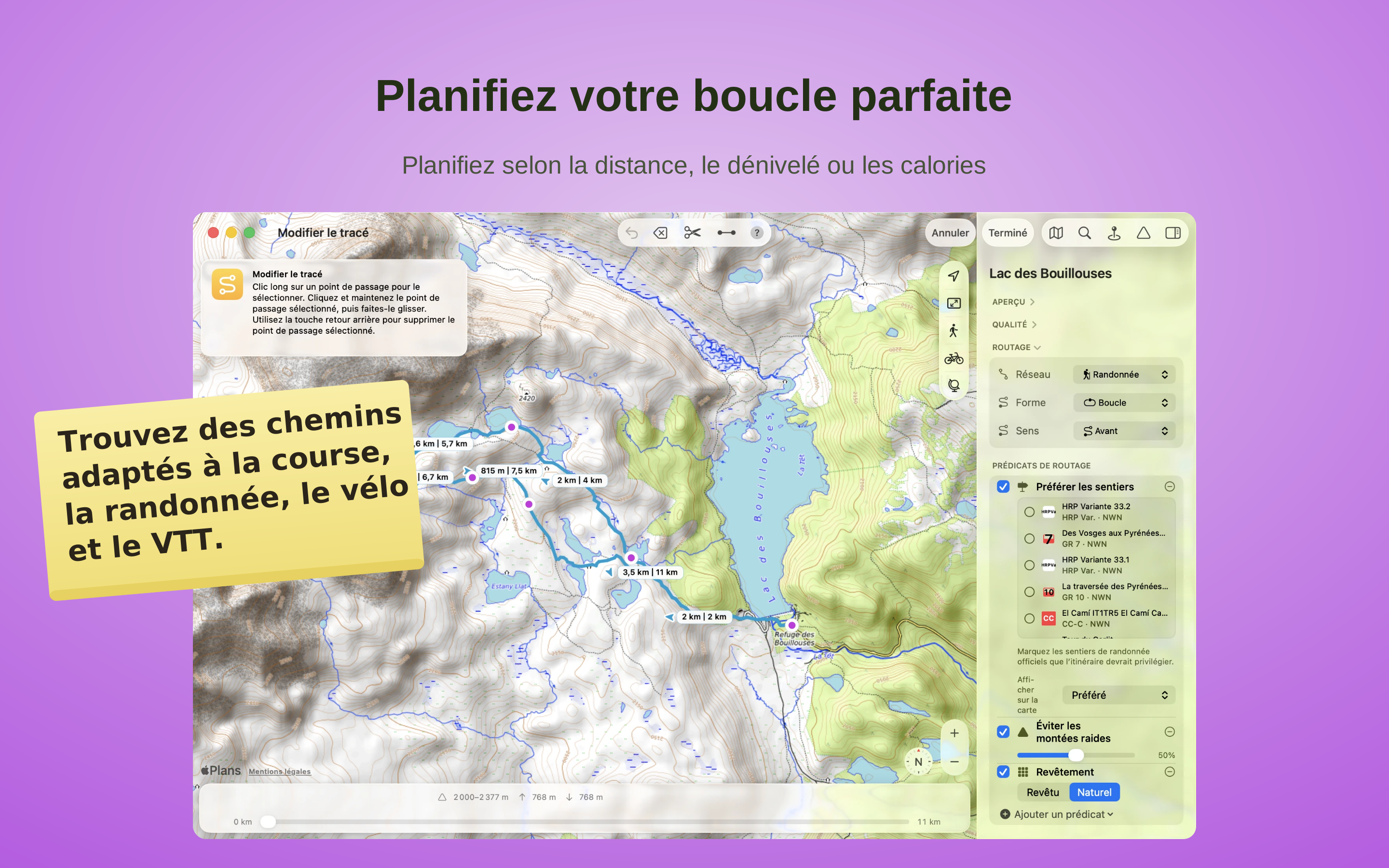
Créez des itinéraires selon vos objectifs – distance, dénivelé ou calories – et trouvez des chemins adaptés à la course, la randonnée, le vélo et le VTT. Lisez la montagne avant de partir : voyez les montées, les descentes et le profil de votre itinéraire avant le départ, et profitez de chaque sortie en sachant ce qui vous attend.

Vos aventures, sur tous vos appareils

Vos aventures, sur tous vos appareils

Importez des fichiers GPX, KML ou Garmin TCX/FIT et transformez-les en votre propre sortie. Modifiez-les, raccourcissez-les ou replacez-les sur de vrais chemins, sans perdre le tracé d’origine. Vos itinéraires, collections et points de repère restent synchronisés entre Mac, iPad et iPhone.

Ce qu'en disent les utilisateurs

★★★★★Général
facile à utiliser
dommage que ça ne detecte pas les doublons
— arncam64 · FR
★★★★★Général
road race
I use always this app for analyze road race circuits. it is very easy to creat and correct map.
— MitchTM · FR
★★★★★Général
Pratique et simple d'utilisation
Je suis ravi de cette application qui est simple d'utilisation et qui donne beaucoup d'informations sur le trajet, par exemple le profil du parcour. Car sur un mobile qui utilise iPhiGéNie, c'est assez compliqué de tracer notre circuit, car l'écran est trop petit donc pas très pratique. Donc je trace sur mon PC avec TrailRunner mini -GPX Editor, cela me permet d'avoir la distance et le profil (dénivelé positif et négatif) du parcour, puis je sauvegarde au format GPX, dans le Cloud, afin de télécharger le parcour sur mon mobile, qui possède l'application "iPhiGéNie", pour suivre la trace sans aucun doute de se perdre durant le parcour.
D'autre part l'abonnement n'est pas cher.
Aussi le tracé du parcour est rapide, car il suffit de donner un point de passage suivant, et il va générer automatiquement le parcour entre le point de passage précédent et le nouveau point de passage suivant, s'il choisit un parcour qui n'est pas celui que vous espèriez, il suffit effacer le dernier point de passage et d'en choisir un autre plus proche du précédent, pour l'obliger à prendre le chemin choisi.
— JR GÉRARD · FR
★★★★★Randonnée
Récupérations de traces
Que ce soit pour mes randonnées à pied ou grandes ballades vélo, la récupération de mes traces GPS sont tres aisées, la visibilité sur trail mini sont très lisibles.... et ceci depuis 2014....
— a galopar · FR
★★★★★Général
Super !!!!
L'application STRAVA pour les itinéraires étant passée payante, j'ai cherché une application pour mes nouveaux traçages. Facile d'utilisation avec celle-ci, juste le dénivelé pas précis. Mais ça laisse le suspens pour les jambes ;)
— Ludal55 · FR
★★★★★Randonnée
Simple et très pratique
Permet de préparer des randonnées en créant des gpx ou en utilisant des gpx existants.Les informations sur l’itinéraire sont complètes et précises.
— Athanagus · FR
★★★★★Vélo
Tout ce qu’il me fallait...
Je cherchais un logicielpour préparer des traces GPX en vue d’un voyage à vélo. la fonctionnalité de traçage automatique est vraiment géniale ! c’est un énorme gain de temps par rapport à des logiciels comme Memory Map (qui de toute façon n’existe pas sur Mac).
— AlainB_ · FR
★★★★☆Général
Super!
Trés précis, je fais les relevés de pistes à partir de mon iPhone, et je les transfère sur mon iMac google earth
— Princeberger · FR
★★★★☆VTT
Mini et pratique: juste ce qu
Ce logiciel est bien pratique pour gérer et créer les traces.
Il est simple, efficace et me permet de bien classer mes traces VTT.
Associé à GPSBabel et LoadMyTracks, il permet de tout faire.

Pas de pb sur lion!
— Potof · FR
★★★★★General
Great to convert
Great to convert kms to gpx and vise versa
— B Giano · US
★★★★★General
TrailRunner mini gpx editor
Using trailrunner to make a video of exciting trip to New Zeland..works well with Google Earth to fill in places where no pics were taken...
— Redwine2205 · US
★★★★★Cycling
Easy to use with lots of functionality
Over the years I've tried several GPX apps for mapping long distance bike routes. I always revert back to using TrailRunner mini.

Practical, intuitive and reliable.
— Speleology · GB
★★★★★Running
great app, awesome on iMac
I train using an old Garmin 305. Garmin Training Center software has not been updated in many years, and no longer works on modern macOS's. So I use an old macOS 10.12 Sierra virtual machine to download my training data from my 305 (using the last version Garmin Training Center), then I export the data as .TCX or .GPX files, which I then import to Trail Runner mini on my modern iMac (2020, running Big Sur 11.7.8), and, voila, all my routes immediately appear on beautifully detailed, interactive maps, along with elevation profile. If you're as old school as all this, I would highly recommend Berbie's app as a way to continue using your favorite old Garmin.
— eo7lus · US
★★★★☆Running
Tracks all my running routes
This is probably the best Mac-based running route app. I use the iOS iSmoothRun on iphone for actually running and export runs to Trailrunner mini via Dropbox. It's nice to see my routes on a bigscreen vs just on my iphone.

The app did hang a couple of times when I tried to import a large number (200-300) of my past exported runs. I did import them successfuly by reducing the number of imports at one time.

I wanted an app that allowed me to export all my run data and Trailrunner mini does this—a hard requirement for me. I refuse to use other apps that lock your data in and prevent you from exporting it. I've been bitten too many times when many apps eventually stop being supported and you lose your data.

The subscription cost is well worth having a good app. Developers need to support themselves too, I don't understand how others can complain that developers should give away their hardwork for free. :–((
— TonisWilson · US
★★★★★General
A really useful app
Great
— PhilLambe · AU
★★★★★Running
Graham Capper
Use it for planning all cycle and running routes and for setting up training sessions for athletes
— Gala Harriers Coach · GB
★★★★☆Running
Very useful app
I find the mapping great - it enables me to see my runs and cycle routes on a big screen.
— daschles · US
★★★★★General
Skillion
Skillion review
— Abyikb · US
★★★★★General
Excellent logiciel
Logiciel très bien fait. Facile d'utilisation. Il comble toutes mes attentes. Bravo.
— Compostelle28 · CA
★★★★☆Hiking
Useful tool...
I use TRm to plan and document hikes and it is capable in this regard. Developer regularly improves/maintains app, and has been resposive to my inquiries. Recommended.
— DanElectroid · US
★★★★★Hiking
Randonnée
Complément indispensable à Basecamp de garmin pour les randonneurs. Facile d’utilisation je suis vraiment satisfait.

Vraiment bon.....incroyablement bien fait et facile d'utilisation merci
— bonoucht · CA
★★★★☆Cycling
Great app for bike trips
I find this app is almost perfect for planning a long bike trip. I can import other people's routes, adjust them, while it tells me distances and elevations along the way. It's snaps to roads easily and intuatively.

But it's one flaw is that the route must go along a known road or major path. Which would be really annoying for runners and mountain bikers who make their own paths.
— ddegner · US
★★★★☆Hiking
I really like this app.
TrailRunnerMini is great for planning walks. It “knows” where the established tracks are and will plot along them.

The tracks can be exported to .gpx or .kml. GPX files will load into apps such as mobileX (Open Street Map) )or Ordnance Survey (UK mapping) on; KML files will open in Google Earth to enable a fly-over of the route. By adjusting the settings in Earth you can really get a feel of the route planned.

The app has improved during the years I’ve been using it. It has easily repaid my investment by giving so much enjoyment.

I occasionally have a problem when I click on a file to open it in the App. Not a big problem but means I give 4* rather than 5*.

Thank you Berbie for an app that really enhances my enjoyment of walking. This year we are in Ireland for our holiday and your app has been a great help.
— 1RedSquirrel · GB
★★★★★Cycling
My go-to bike app
Have used this for a few years now and it’s my go-to app for bike mileage. It covers the basics well and I consider it easier to use than the Garmin online offering. Use it for my Garmin Edge 200.
— mbrfan · GB
★★★★★General
Trailrunner mini
Use it all the time, I don’t know what I would do without it.
Loads of fun to map out new routes.
— Crazy Eskimo · CA
★★★★☆Cycling
Bike guide
I’m a bike guide and I find this a very useful app to help me with the disigning and mapping of routes. I find it especially useful to show my clients what the days ride will look like. It’s easy to use, very recommendable!

One glitch! it happens on both my computers, The program crashes every now and then, I’m sure the team are on that!
— jceb34 · GB
★★★★★Running
Awsome app!
I've been using trailrunner mini for about 1 year now and it has grown to be an essential part of my fitness lifestyle. During my marathon training I used it on a daily basis for mapping daily courses, ensuring that I get my planned milage. Now I use it to plot morning running routes to get the most of my PT time before work, making sure I'm not going out too far and be late to the office. Great tool that I could not live without!
— Deepsiks · US
★★★★☆General
Update needed
The August 2012 release had a flaw that caused it to crash. Berbie has confirmed he is working on a fix, to be released shortly. Until then, the system may or may not work, not sure if the flaw was an OS issue or something else.

However, once fixed, I must say this is the best mapping app I have used - and once it failed and I spent an afternoon trying to find another equivalent app, I realized how much I liked TRM. Simple way to trace and create maps - it is a bit bulky in how it loads map data at smaller scales, but works extremely well. Unless I'm missing a few apps, I have tried as many of the affordable ones I could, including the giant's online free sources, and find this to be the best. Company service was quick and prompt, although it seems to be a fairly small operation, Berbie seemed concerned to get it right as soon as he could.

Now let's hope the update comes soon. 5 starts once that is dealt with.
— WesterEdge · CA
★★★★☆Running
Very useful map app
This is a very useful app for planning route to walk, run or cycle. It's pretty accurate when it comes to elevations let alone distances. It's exactly the app I was looking for to use on my Mac.

The reason I have given it four stars instead of five is the syncing with RaceBunny for the iPhone. I have had the odd little issue with this but there is help on the internet at the developer's website and if you search Google. One thing to note on the syncing, it is working perfectly for me right now and has been for a while.

Overall, very happy with the price for the app. Keep up the good work Berbie Software.
— tarmyg · GB
★★★★☆Running
Great alternative to mapmyrun, although occasionally sluggish
I've used MapMyRun for a while, and long been frustrated at its glacial development progress and buggy interface. So TrailRunner mini is a great alternative - and also great not to have to endure ads and/or punitive membership fees just to create a running route. Only complaint is with the routing - particularly for longer sections, the follow-roads (or paths) route plotting can be incredibly slow. But for this price, I guess we shouldn't expect lightning fast performance.
— OFuser · GB