routes
Background routes
2018-06-19 10:28 Stored in:Help
When you select a route in TrailRunner mini, the course is displayed in the map. But sometimes you may want to permanently display the route in the map, e.g. for planning alternatives or by making them visible as your path to follow when using RaceBunny while you are on your way biking or hiking.
You either flag a route by selecting the flag in the right information area or by selecting the flag in the left list of routes:
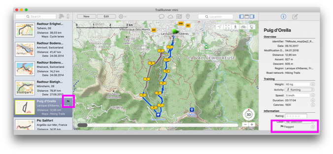
You either flag a route by selecting the flag in the right information area or by selecting the flag in the left list of routes:
Extended Route Notes
2018-01-22 16:47 Stored in:Help
With TrailRunner mini 3.6 and above, you can add additional notes and attachments to routes. These are multiple images, text fragments and links to websites or any file on your hard drive.
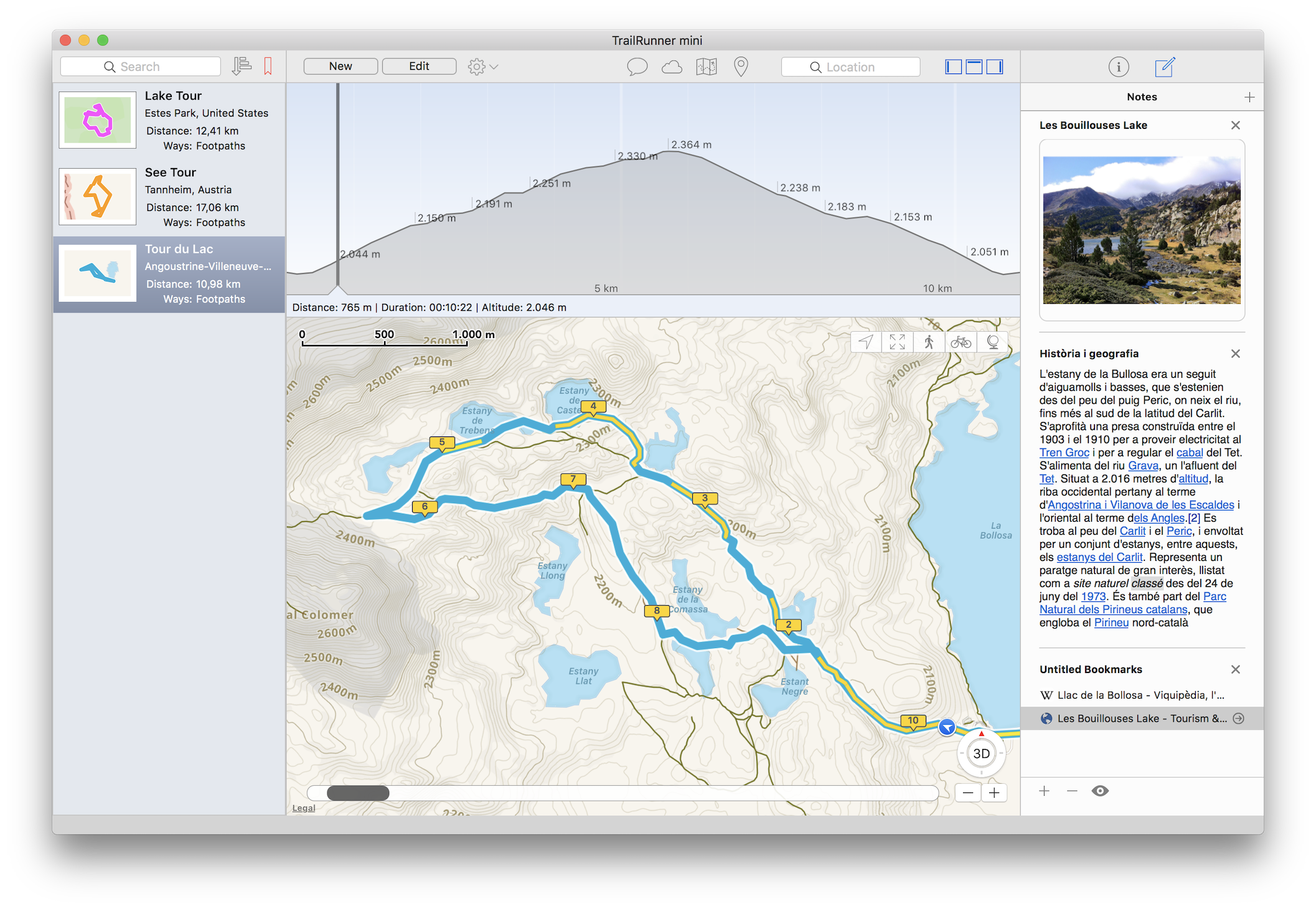
To use this feature, select a route. In the right info area select the notes icon. Then either drag anything into this area or add a container by clicking the top right + icon.
Once you have added multiple containers you may reorder them by clicking and holding within the background area of a container until the container starts hovering and then dragging the container to reorder it.
This feature is free to all users that have bought a subscription and for users that have bought a lifetime license for TrailRunner mini 3.6 and above. Users that have bought a license prior the 3.6 release have to buy a subscription.
How does TrailRunner mini import and export the GPX file format
2019-03-24 19:38 Stored in:Conceptual
The GPX file format (https://en.wikipedia.org/wiki/GPS_Exchange_Format) is an open standard that describes geographic information.
Within that format there is a conceptual difference between three types of point information:
Whenever you export files from external sources and import them in TrailRunner mini, try to keep the data straight within the expectations of TrailRunner mini. Some applications may export tracks as a series of wpt-tags which leads to serious misunderstandings within TrailRunner mini.
There are some type conversion tools out there that may help. Like http://www.gpsbabel.org
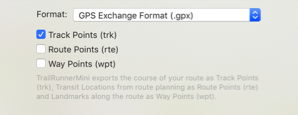
When you export routes in the GPX format to be displayed on other devices, the same applies. Some apps may not make a difference between track/route and way-points and may display all at the same time. To avoid this, you most likely want to export your route containing trackPoints only.
Read more:
• What are landmarks and waypoints?
Within that format there is a conceptual difference between three types of point information:
- Track-Points:
this is a raw recording representing a course. TrailRunner mini creates track-points as a result of a calculated route (the course you see on the map) - Route-Points:
: this represents a stop point on a route and is represented as a transit location (routing pin) in TrailRunner mini. Given two transit locations, TrailRunner mini calculates a track between these using the OpenStreetMap Network. - Way-Points:
this represents a landmark in TrailRunner mini.
Whenever you export files from external sources and import them in TrailRunner mini, try to keep the data straight within the expectations of TrailRunner mini. Some applications may export tracks as a series of wpt-tags which leads to serious misunderstandings within TrailRunner mini.
There are some type conversion tools out there that may help. Like http://www.gpsbabel.org
When you export routes in the GPX format to be displayed on other devices, the same applies. Some apps may not make a difference between track/route and way-points and may display all at the same time. To avoid this, you most likely want to export your route containing trackPoints only.
Read more:
• What are landmarks and waypoints?
Gradient overlay colors
2016-05-20 12:10 Stored in:Help
TrailRunner mini can display a color overlay that visually describes the gradient at a given route section. The color coding goes from yellow to red within the range of 5% gradient to 35% gradient.
You can turn the gradient overlay on and off in the maps toolbar menu.

Please note that there are some technical limitations on the accuracy of the gradient because the underlying elevation data is not very accurate at all times. TrailRunner mini therefore calculates the gradient within smoothed intervals.
| 5% | 20% | 35% |
You can turn the gradient overlay on and off in the maps toolbar menu.
Please note that there are some technical limitations on the accuracy of the gradient because the underlying elevation data is not very accurate at all times. TrailRunner mini therefore calculates the gradient within smoothed intervals.
What are Region Collections
2016-02-07 00:53 Stored in:Tutorial

You can click on one of those markers and get a detail view with all contained routes and landmarks displayed in an overview map.
Selecting one of the routes in the left list will zoom the map to display that route. To return back to an aspect where you again can see Region Collection markers on the map, click the globe icon in the map controls.
When you choose to Show Routes in that region, the left list of routes is filtered to display these routes for you to explore.
You can remove that filter by choosing Show All in the top toolbar item for Route Collections.
Please note that Region Collections are an extended feature and that you can only use one for free. Full region collections require a one time in app purchase that lets you explore as many Region Collections as being displayed on the map.
What are dynamic collections?
2016-02-06 22:35 Stored in:Tutorial
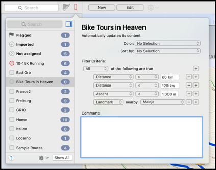
Collection of all biking routes with a distance of 60 - 120 km and less than 1000 meter of ascent and nearby a specific landmark like the parking spot you usually start from.
To create a Dynamic Collection like the above, click on the collections toolbar icon and in the action menu select New Dynamic Collection.
Within the rules editor, build a configuration like this:
To better identify your collection (besides the name) you may set a color for the icon displayed in the collections menu. Also you can define in which order the collected routes are sorted.
Please note that Dynamic Collections are an extended feature and that you can only create one for free. Additional dynamic collections require a one time in app purchase that lets you create as many dynamic collections as you need.
How can I organize my routes in folders or collections?
2019-08-08 14:56 Stored in:Help
Problem: you have a lot of routes and want to organise these in folders or collections.
Solution: TrailRunner mini has a simple feature you can use to group routes in collections. Just right-click (or select a route and choose open the action menu) to move the route to any of your collections.
Alternatively open the collections popover and drag one or multiple selected routes to any of your collections. Note that you can also tear-off the popover into a freestanding window by tearing the popover off at its top.