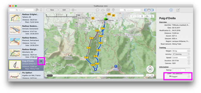
Background routes
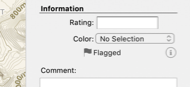
You either flag a route by selecting the flag in the right information area or by selecting the flag in the left list of routes:
How can I add a trail that is missing on the map
Contribute: OpenStreetMap is like wikipedia for maps. Everyone can contribute, extend and correct the maps. There is a very convenient editor existing you may use to edit the open openStreetMap maps.
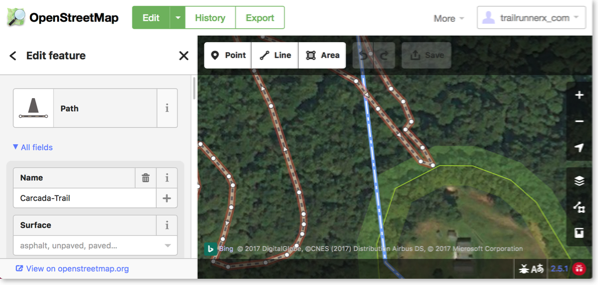
After making changes to OpenStreetMap, it takes a couple of hours until your changes have have made it into the routing engine of TrailRunner mini.
As TrailRunner mini may still have cached the old data, use TrailRunner mini > Clear Caches… to make sure the new data is downloaded and becomes visible in the map.
Alternatively you can build a local missing link by creating an off-road section within your planned route.
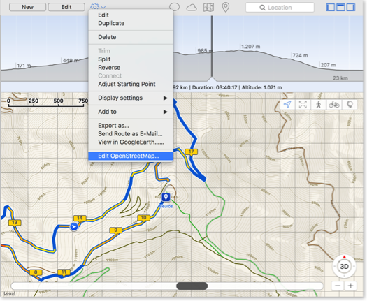
How can I split a route or concatenate fragments?

Trim
Select a route and also select a range in the elevation chart. Then choose the command to trim the route to the selection in the chart.
Split
Select a route and also select a location in the elevation chart. Then choose the command to split the route at the selection into two route fragments.
Reverse
Select a route and choose the command to reverse the course direction. In other words to make the end point the new start.
Concatenate
Select two route fragments and choose the command to join the two fragments into one concatenated route.
Adjust starting point
Select a route, preferably a round trip, and select a location in the chart. Then choose the command to set the starting point of the round trip to the select position making the old start point a simple transit location on the course of the resulting route.
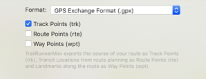
How does TrailRunner mini import and export the GPX file format
Within that format there is a conceptual difference between three types of point information:
- Track-Points:
this is a raw recording representing a course. TrailRunner mini creates track-points as a result of a calculated route (the course you see on the map) - Route-Points:
: this represents a stop point on a route and is represented as a transit location (routing pin) in TrailRunner mini. Given two transit locations, TrailRunner mini calculates a track between these using the OpenStreetMap Network. - Way-Points:
this represents a landmark in TrailRunner mini.
Whenever you export files from external sources and import them in TrailRunner mini, try to keep the data straight within the expectations of TrailRunner mini. Some applications may export tracks as a series of wpt-tags which leads to serious misunderstandings within TrailRunner mini.
There are some type conversion tools out there that may help. Like http://www.gpsbabel.org
When you export routes in the GPX format to be displayed on other devices, the same applies. Some apps may not make a difference between track/route and way-points and may display all at the same time. To avoid this, you most likely want to export your route containing trackPoints only.
Read more:
• What are landmarks and waypoints?
How can I adjust a suggested route course
Solution: insert additional transit locations to give TrailRunner mini a hints on the route course you have in mind.
What are landmarks and waypoints?

- Just a geographic bookmark (or point of interest) you can set for yourself. Add landmarks to easily jump to a location by selecting the landmark in the landmarks popover.
- A shortcut for routing. Within this context a landmark becomes a waypoint.
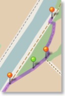
Route and Landmarks. The following quick tutorial shows how you start a new route from an existing landmark. Then, during routing, the tutorial shows how a new landmark is being added and how the route returns to the point where you have started.
Please note that the route created used two intermediate transit location pins to direct the routing over the specific course of the demo.
So it's basically a route from the starting landmark ➜ over a transit pin ➜ to the newly created signpost landmark ➜ over a second transit pin ➜ and back to the starting landmark. (Expert users could have used the roundtrip setting in the left route planning pane to omit the last step)
Landmark Intelligence. When you connect two landmarks (even by placing intermediate transit location pins) TrailRunner mini remembers the course you have chosen to reach a landmark outgoing from a previous landmark. After this has happened (and as soon as you create a route that follows the same course of landmarks) TrailRunner mini will be able to directly connect the two landmarks — based on the memorized course. No intermediate transit locations required. The second quick tutorial shows how that happens:
Shortest vs. favored. If you are not very accustomed to how routing without landmarks works, just realize that routing in TrailRunner mini uses the shortest path to reach one transit location to another. But that's typically not what you want. So what happens is that you are always compelled to insert intermediate transit locations until the course matches your intention. Now as landmarks remember their connections to other landmarks, this manual correction is only required once. So what you could do now is that you place some hot locations on your map (that you regularly come along during your workout courses) and TrailRunner mini will automatically connect these with the courses you planned in the past — and not the course that is shortest.
Offroad-Routing. The other effect that comes in useful is that landmark to landmark courses can contain off-road transit locations. So whenever the underlying map source is incomplete, just layout an off-road course between two landmarks and TrailRunner mini will extend the map coverage by your means.
Offline-Routing. As landmarks memorize their past connections to other landmarks in the map, no network requests are being fired to route between two such landmarks. This effectively gives you limited off-line routing.
Export and Import. Routes created in TrailRunner mini that make use of landmarks will contain these as waypoints in exported GPX files. Importing GPX files containing waypoints (wpt-tag) will also import these as landmarks. To learn more about the GPS eXchange Format, read its wikipedia article.
Summary. That's basically all you need to know about landmarks in TrailRunner mini. To learn more, check out the additional information provided in the landmarks popover, next to the landmark attributes.
Live or let die. Please note that I create TrailRunner mini in my spare-time. So if you have feedback and questions, contact me directly via application feedback. If you like TrailRunner mini, please spend some stars on the AppStore review. Have fun.
Can you add more map sources?
Explanation: TrailRunner mini is based on the OpenStreetMap project. When you create routes, TrailRunner mini follows a hidden network of trails and streets that is based on OpenStreetMap data. The same data is being used to render the visible map. Would I add different map sources like Google Maps, the trail or street may be visible to you but you still cannot use it within the routing editor. This would be very frustrating and therefore I will not add this feature to TrailRunner mini — just because the App is supposed to be a simple route planning tool and no professional mapping solution.
Hint: But what you can do is to contribute to the OpenStreetMap project and fix the problem at its root.
Update: In recent builds of TrailRunner mini and RaceBunny you can choose between different map Sources. But please understand that these still are based on the openStreetMap project data and therefore cover the same level of detail, though the design may differ.
Expert Hint: When you click on the map toolbar icon in TrailRunner mini, select the option to display more map sources. Then choose any of the available. But please understand that these may display different data than the routing editor can display. If that is the case you may use the off-road routing feature to follow these ways.
How can I edit an imported route
Files imported in the format GPX, KML, TCX or FIT are typically recordings. These recordings are immutable in a way that they contain many recorded points with no logical connection to the OpenStreetMap network that underlies the TrailRunner mini routing editor.

So when you try to edit such a route, TrailRunner mini gives you the option to create a routable approximation of the route by guessing good transit locations that resemble the original as much as possible. You can even choose to display the original recording as a background route to compare and make corrections to the approximation.
Read more:
How can I create off-road routes?
Solution: In the left editor panel, turn on the off-road switch. All now placed transit location pins are now green off-road pins that no longer follow the openStreetMap network. As an alternative, while moving or adding a transit-location, hold the (Command / ⌘) key down to place an off-road transit location. TrailRunner mini will then create a straight connection between the last transit location, the green off-road transit location and the upcoming transit location.
HowTo: Watch this video guide on how this works.
Contribute: To improve the mapping coverage of this area, you may want to contribute to the openstreetmap.org project. Layout the "missing link", export a GPX file and upload it to the openStreetMap network. It may then take up to two weeks until the track is available within TrailRunner mini. If that's not the case, remove the TrailRunner mini Cache from your hard-drive.